Editor's note: As the nation celebrates 250 years of existence, we look back to the 250th anniversary of the founding of St. Louis. This series was originally published in 2014.
Some time after the Beginning, much of what we call the Midwest was covered by a warm, shallow ocean. Millions of years of sediment and the remains of primordial creatures formed the limestone we rest upon.
Achingly slow collisions of continents pushed the land out of the water. Volcanic bulges created granite heights such as the St. Francois Mountains (near Farmington, Mo.). Dinosaurs roamed, just as the children’s books always say they did. The sea retreated south to the wide Delta flatland of the Bootheel.
The geological evidence suggests all of that took about 2 billion years, give or take a few million.
A series of ice ages beginning about 2.5 million years ago ground up the land roughly as far south as St. Louis, gouging valleys for massive runoffs of melt that created major rivers — including the Missouri, Mississippi and Illinois, which merge into the fertile bottomland of the great confluence. The last glacial retreat, 12,000 or so years ago, left behind the meandering river courses framed by the high limestone bluffs we know today.
People are also reading…
The strategic convenience of the confluence attracted humans. The earliest evidence in this area is of arrowheads that were found at Mastodon State Park near Imperial, where nomadic clans probably killed mastodons for food 10,000 or 12,000 years ago. There’s not much more to go on.
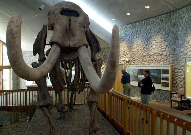
A replica of a mastodon skeleton on display in the museum at the Mastodon State Historic Site in Imperial. Archeological evidence unearthed at the state park in Jefferson County is the oldest showing that humans hunted mastodons in this area, roughly 10,000 years ago. Photo by Sam Leone
The first clear indications of permanent settlement were the large earthen mounds that once dotted the land on both sides of the Mississippi. Only a few are left, the largest being Monks Mound near Collinsville. Clusters of mounds were constructed north of downtown and in East St. Louis, but later American settlers obliterated them.

Monks Mound, the largest of the Cahokia mounds, in 1923, when the Illinois Legislature approved buying land for a state park to preserve the site. The mound covers about 14 acres. It now is part of the Cahokia Mounds State Historic Site. Post-Dispatch file photo
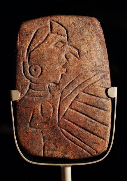
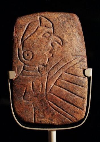
The Birdman tablet was found on the east side of Monks Mound at the Cahokia Mounds State Historic Site in Collinsville. The 4-inch-tall sandstone carving shows a man with a bird-like mask, possibly a falcon dancer. On the back are cross hatchings possibly symbolizing snake skin. The tablet possibly embodies a creature of the underworld, the snake; this world, the man; and the upper world, the bird. The birdman tablet is on display at the interpretive center at the Cahokia Mounds State Historic Site and has been adopted as its logo. Photo by Jerry Naunheim Jr.
The glory years of the Cahokia settlement, when it was a major city and trading center, ran for three or four centuries until about 1300 AD. Its people traded along the major waterways all the way to the Gulf of Mexico. Then they disappeared. No one knows why.
No tribe took their place with major settlements, but bands of Osage and Missouri regularly hunted along the Mississippi.
The first Europeans to pass by the future St. Louis were Jesuit Father Jacques Marquette and explorer Louis Jolliet, who drifted down the Mississippi River in 1673. French explorers soon claimed the river for their king. In 1699, his missionaries established the Holy Family church at present-day Cahokia, near a small village of Tamaroa Indians.
Other missionaries settled for a few years at the mouth of a small tributary known ever since as the River Des Peres — the River of the Fathers.
French colonists established other posts, including Ste. Genevieve and Fort de Chartres. In 1763, their king ceded the land east of the Mississippi to the British as spoils of the French and Indian War. (He also secretly deeded Louisiana to Spain, but nobody over here would learn that for nearly two years.)
In New Orleans, business partners Gilbert Maxent and Pierre Laclede obtained the colonial monopoly for fur trading in upper Louisiana colony. Laclede prepared for the long journey upriver to establish a trading post.
His destination was the great confluence.

A Look Back • A perfect spot for the trading post that became St. Louis
Satellite view of St. Louis, 1991

The St. Louis area as seen from space in a 1991 NASA image. See the full-size image here. The Missouri, Mississippi and Illinois rivers, originally runoff from melting glaciers, merge into the fertile bottomland of the great confluence. The city was founded on high land just to the south.
Topographic map of St. Louis

A topographic map of St. Louis and points west produced by radar from Space Shuttle Endeavour in 2000. The Missouri, Mississippi and Illinois rivers, originally runoff from melting glaciers, merge into the fertile bottomland of the great confluence north of St. Louis.
National Great Rivers Museum

Visitors to the National Great Rivers Museum in Alton study a wall map of the confluence of the Mississippi and Missouri rivers in this October 2003 photo. The Army Corps of Engineers Museum is next to Lock and Dam No. 26. Photo by Karen Elshout of the Post-Dispatch
Mastodon State Park
A replica of a mastodon skeleton on display in the museum at the Mastodon State Historic Site in Imperial. Archeological evidence unearthed at the state park in Jefferson County is the oldest showing that humans hunted mastodons in this area, roughly 10,000 years ago. Photo by Sam Leone
Artist's conception of Cahokia Mounds

A painting depicting what life may have been like at the Cahokia settlement in the days of the Mississippian civilization, which faded about 1300. Image courtesy Cahokia Mounds State Historic Site
Artist's conception of Cahokia Mounds

Cahokia Mounds State Historic Site - looking between the Twin Mounds, across the Grand Plaza with a chunkey field to Monks Mound, by Lloyd K. Townsend
Birdman tablet
The Birdman tablet was found on the east side of Monks Mound at the Cahokia Mounds State Historic Site in Collinsville. The 4-inch-tall sandstone carving shows a man with a bird-like mask, possibly a falcon dancer. On the back are cross hatchings possibly symbolizing snake skin. The tablet possibly embodies a creature of the underworld, the snake; this world, the man; and the upper world, the bird. The birdman tablet is on display at the interpretive center at the Cahokia Mounds State Historic Site and has been adopted as its logo. Photo by Jerry Naunheim Jr.
The Mississippians left behind questions and the bones of their revered dead.

The Keller Figurine was found in Collinsville near the Cahokia Mounds complex. The figurine, dated from 1100 to 1150, is carved bauxite in the form of a young girl kneeling with a basket or a rain cloud in front of her. The arms may have been broken off intentionally at the time of burial to release the spirit of the figurine.
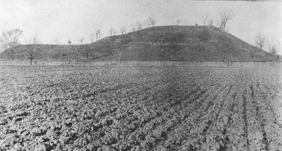
Monks Mound 1923
Monks Mound, the largest of the Cahokia mounds, in 1923, when the Illinois Legislature approved buying land for a state park to preserve the site. The mound covers about 14 acres. It now is part of the Cahokia Mounds State Historic Site. Post-Dispatch file photo
Monks Mound, 1984

Visitors climb the wooden stairs to the top of Monks Mound in 1984. It is the largest of more than 70 mounds of the Cahokia Mounds State Historic Site, just west of Collinsville. Post-Dispatch file photo
Monk's Mound gives birth to the sun

SATURDAY, SEPT. 25, 1999 - As the sun rises Saturday morning, a line of marchers ascends the long staircase leading to the top of Monks Mound at Cahokia Mounds State Historic Site. The marchers were participating in a celebration of the autumnal equinox. Many carried flags bearing the logo of "2000 - A Millennium Journey."
Monks Mound

The sun rises over Woodhenge at Cahokia Mounds State Historic Site in Collinsville on Sept. 25, 1999. Woodhenge is a reconstruction of a huge, ancient circle of enormous red cedar posts. Evidence of the original was unearthed in 1961 at the site west of Monks Mound, seen at the left in the background. Most scholars believe it was a solar horizon calendar that enabled the Cahokians to track the sun's movement as a way of determining important dates. Photo by Jerry Naunheim Jr.
Monks Mound

Volunteer tour guide Roger Smith leads a group to Monks Mound at Cahokia Mounds State Historic Site on Aug. 22, 2008. Photo by Laurie Skrivan, lskrivan@post-dispatch.com
Monks Mound stairs

Students from Washington School in Marion, Ill., take a break as they climb Monks Mound during their field trip to the Cahokia Mounds State Historic Site on May 9, 2000. They had also visited the Arch. Photo by Odell Mitchell Jr. of the Post-Dispatch
Artist's conception of Cahokia Mounds

A bird's eye view of what the Cahokia settlement of the Mississippian civilization may have looked like. Monks Mound is at the center. To the left is a post circle thta probably served as a solar calendar, such as Stonehenge in Great Britain. Image courtesy Cahokia Mounds State Historic Site
Big Mound in 1852
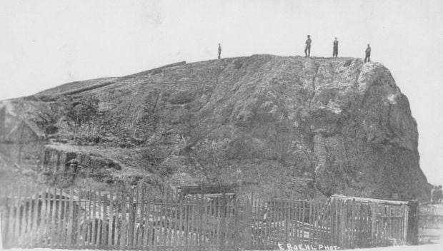
Big Mound in 1852, showing erosion and removal of some of its earth to make way for a street. When St. Louis' founders arrived, the mound at today's North Broadway and Mound Street was the largest and northernmost of a cluster of 25 mounds. It measured 319 feet long by 158 feet wide, and was 34 feet high. Final destruction began in November 1868 to provide fill dirt for the North Missouri Railroad, running along the Mississippi River. Missouri History Museum photo
Sugar Loaf Mound
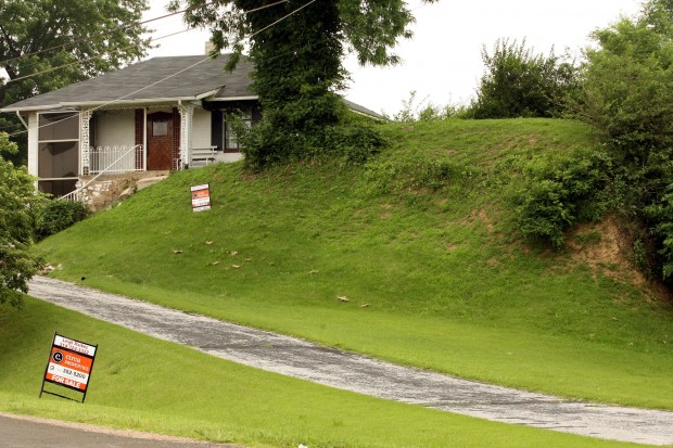
Sugar Loaf Mound, the last Mississippian mound left in St. Louis, at 4420 Ohio Street near Interstate 55, in a 2009 photo. The Osage Nation of Oklahoma bought the home that year. Photo by Christian Gooden, cgooden@post-dispatch.com
View from Lewis and Clark Hartford Tower

The confluence of the Mississippi and Missouri rivers as seen from the 150-foot level of the Lewis and Clark Hartford Tower in Hartford. The rivers are nearly at flood stage in this photograph, taken in 2010. Photo by Stephanie S. Cordle, scordle@post-dispatch.com