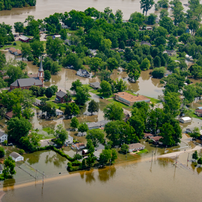

The National Weather Service (NWS) is warning St. Charles County residents to be prepared for possible flooding linked to major rain events, even though its official outlook predicts only low-to-moderate flood risk.
"We’re pretty much at the mercy of whatever rainfall happens going forward," says NWS Senior Service Hydrologist Mark Fuchs.
The NWS official outlook through June 28 in St. Charles County shows the likelihood of flooding along the Missouri and Mississippi rivers and along the Dardenne Creek, based on water levels, soil conditions and historic data.
Fuchs says St. Charles County should be OK if rainfall amounts stay within historic averages here:
- May: 5 inches
- June: 4.5 inches
- July: 4 inches
- August: 3 inches
There is also the concern of heavy downpours upriver leading to possible flooding here.
People are also reading…
"All it takes is one storm to change things," Fuchs says. "In July of 2022, we had over a foot of rain in a 24-hour period. That’s the kind of thing we have to be prepared for."
Fuchs recommends getting a National Oceanic and Atmospheric Administration (NOAA) weather radio to monitor for severe weather alerts.
"If you live in a flood zone where the probabilities are higher, you have to be more diligent," Fuchs says. "You want to be more aware of the potential threat on a day-to-day basis and be ready for it."
Experts also recommend cleaning out gutters and basement stairwell drains so they can handle heavy downpours.
New webpage to gauge your property’s flood vulnerability
Meanwhile, St. Charles County is debuting a new flood webpage to help you find the flood facts of most properties in St. Charles County. If a river runs close by, or the yard hugs a creek, chances are that property you are thinking of buying has a flood history.
The new webpage answers your questions about flood-prone properties across unincorporated St. Charles County, where 43% of the land is in a flood plain. The database includes more than 170,000 parcels, with information going back to the flood of 2019. Each year, more than 500 floodplain properties go on the market in St. Charles County.
Among the data you can now find by searching an address:
- What to do if your property just flooded
- Learn your flood risk
- Where are the 100-year and 500-year floodplains
- Recent history of flood damage
- Flash flooding information
- Elevation and building data used in flood risk analysis
The webpage brings together Federal Emergency Management Agency (FEMA) flood maps, County parcel data and elevation records into one place. This allows residents to see more complete and up-to-date information about a property than before.
The webpage also helps emergency responders by mapping flood-affected structures block by block during a disaster, allowing responders to identify vulnerable properties. Residents can report flood damage directly through the same portal, giving emergency responders real-time information.
This initiative is part of a broader County effort to modernize floodplain management following the 2019 flood. The goal is to encourage better redevelopment and increase public access to hazard data for planning.
Through federal Community Development Block Grant–Disaster Recovery (CDBG-DR) funding, the County is investing in projects that reduce future flood risk, including voluntary property buyouts and improved planning when offered by federal agencies.